")
")
Confidential Client
Conceptual Farm Design and Permitting for 300 thousand acres.
In 2005, RCS provided technical guidance to a planning analysis to forecast the next 20 years of water needs for a ± 300,000 acre ranch in Central Florida. These water use projections were to be used for a SJRWMD evaluation of available future water supply. The project involved data collection and analysis of a large amount of GIS information, including topography, cover, soil type, wetlands, and features pertinent to agricultural use potential. RCS then performed an initial appraisal, reviewing the consolidated information to determine broad categories of agricultural uses that may be considered for the Ranch in years to come. A simplified water use data base for various agricultural operations was a crop irrigation model and various water use permitting guidelines. With this database, RCS generated estimates of net water demand for the scenarios deemed economically viable.
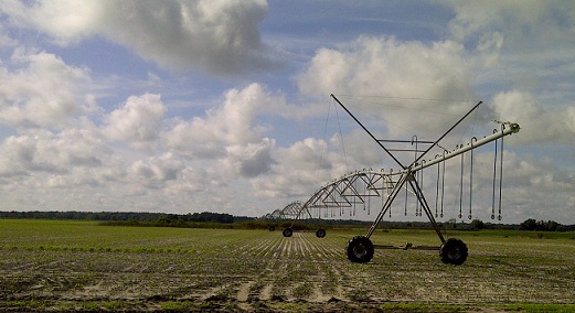
In 2008, RCS began to provide agricultural engineering expertise to the Ranch’s agricultural expansion planning project as well as the drainage design and permitting for the first set of center pivot irrigation fields. The agricultural expansion planning effort required consideration of a wide variety of factors that would affect the overall success of these operations. These factors included soil type and fertility, land slope, wetlands and finding large contiguous pieces of land, water supply infrastructure and potential limitations, roads, and electrical power. For the drainage design of the first set of center pivot irrigation fields, RCS used fieldand ditch survey data to develop a SWMM surface water model to evaluate the potential for flooding. Since flood duration is typically more important than peak flood stage in agricultural settings, the results were communicated in terms of duration that a particular area would be flooded. Following this effort, an extensive field data collection was made to collect estimates of ditch depth and relevant hydraulic features (e.g. culverts) to develop a regional stormwater model for the entire area planned to have center pivots.
It was envisioned that portions of the model would be used as a starting point for more detailed drainage design efforts as the rest of the pivots are constructed. RCS continues to lead the SJRWMD ERP permitting and agricultural ERP exemption determination efforts for the proposed drainage and water supply improvements for this project.
In addition, RCS has provided and continues to provide support for the CUP permitting efforts related to this expansion. These efforts included an analysis of the District’s GWRAPPS program relative to the numerous types of crops anticipated to be grown. Since the list of crops and potential growing seasons was designed to be flexible, a customized Blaney-Criddle analysis was developed to more efficiently manage this effort. In addition, RCS provided groundwater modeling services and managed several RAI responses using information provided by a variety of sub consultants.